
The monsoon is life in South Asia. It fills rivers and reservoirs. It waters fields and forests. It sets prices for food. It decides if a village has water for the year. But the monsoon can also bring danger. When rain is too heavy, or falls in the wrong place, it can turn into disaster.
Monsoon 2025 is one of the most unpredictable in recent memory. August 2025 brought unusual rain patterns and many floods. Some dry areas got a big surplus. Some wet hills stayed dry. Cities struggled with cloudbursts. Mountain roads broke under landslides. Families lost homes and crops. Many ask why this happened and what it means. This post explains the key events and patterns in India and Pakistan, and what they tell us about climate change in South Asia.
India: When Dry Regions Turned Wet, and the Wet Northeast Turned Dry
Rajasthan and Ladakh: Surplus rain in arid lands
- India rainfall surplus 2025 stood out in the northwest. Rajasthan, normally very dry, saw repeated heavy spells.
- Ladakh, a cold desert, also saw surprising rain. Mountain slopes got soaked and then failed in places.
- Why it happened: The monsoon trough often sat farther west and north. Warm Arabian Sea waters added extra moisture. Some western disturbances met the monsoon winds and made the clouds stronger.
- Impacts on people: In Rajasthan, farm ponds filled, tanks overflowed, and soil moisture improved. This is good for kharif crops like bajra and guar. But waterlogging damaged some fields and village roads. In Ladakh, short cloudbursts triggered small flash floods in dry channels. Traffic stopped on key passes. Supply trucks waited for days as crews cleared mud and rocks.
Meghalaya and the Northeast: A rare deficit
- Meghalaya is famous for very high rain. In August 2025, parts of Meghalaya and the Northeast had a deficit.
- Fewer low-pressure systems came in from the Bay of Bengal. Many active spells went north and west instead.
- Impacts on people: Tea estates and small farms faced stress in pockets of Assam and Meghalaya. Springs and small streams ran lower than usual. Some hydropower plants reduced output. Communities that depend on regular rain had to plan for water-saving and staggered planting.
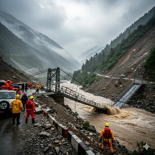
Himalayan landslides 2025 near Vaishno Devi
- Several days of intense rain hit the Jammu hills near the Vaishno Devi pilgrimage route.
- Local authorities reported deadly landslides and rockfalls. Dozens of people lost their lives, and many were injured. Rescue work was hard because the terrain is steep and the soil was saturated.
- Impacts on movement: Pilgrim routes shut down at times. Mountain roads were cut. Ambulances and supply vehicles had to take long detours. This event shows how fragile hill roads are during extreme rain.
India’s wettest monsoon since 2013? Early signals say yes
- By late August, early assessments pointed toward the wettest season since 2013 for India as a whole.
- The story is not only the total. It is the skew. Rajasthan and Ladakh saw surplus rain. Meghalaya and some Northeast districts saw a shortfall.
- Final numbers depend on September, but the August 2025 floods and anomalies already mark Monsoon 2025 as a standout year.
Pakistan: From Mountain Flash Floods to Urban Deluge
Khyber Pakhtunkhwa flash floods: Swat, Buner, Bajaur
- Pakistan monsoon floods hit Khyber Pakhtunkhwa hard. In Swat, Buner, and Bajaur, cloudbursts sent walls of water down narrow valleys.
- Steep slopes shed water very fast. Roads, footbridges, and irrigation channels washed out. Small hydel plants were damaged. Villages were cut off for days.
- Human impact: Families moved to schools and mosques for shelter. Shops, clinics, and small hotels by rivers took heavy losses. People who survived past floods faced trauma again, with homes and savings at risk.
Punjab Pakistan floods: Worst since 1988 for many communities
- Wide areas of Punjab saw long-duration flooding in August 2025. Many communities called it the worst since 1988.
- Rivers stayed high. Water sat in fields and villages for days.
- Cross-border factors: High inflows and reservoir safety led to dam releases upstream in India. Downstream in Pakistan, people felt the surge added to the flood. Indian operators noted they follow rule curves and safety needs. Pakistani authorities said releases made local flooding worse. This remains a point of tension.
- Farm losses: Cotton and rice suffered. Cotton lint quality dropped after waterlogging. Paddy fields had lodging and disease risk. Fodder shortages hit livestock keepers.
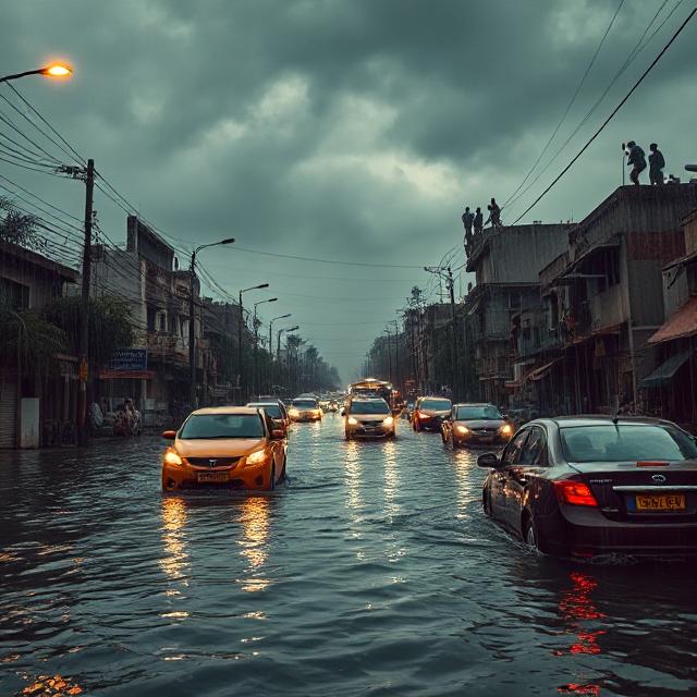
Karachi and other cities: Cloudbursts and urban flooding
- Karachi saw multiple cloudbursts. In a few hours, rain totals matched a normal month.
- Drains clogged with waste could not carry the water. Underpasses flooded. Traffic stopped. Power cuts spread as substations and cables got wet.
- Health impacts: Stagnant water raised the risk of water-borne disease. Clinics, dialysis centers, and pharmacies struggled to stay open. Similar patterns hit other cities and towns across Pakistan.
Climate Change South Asia: Why Monsoon 2025 Looked So Different
A warmer background makes extremes stronger
- Warmer air holds more moisture. Roughly 7% more water vapor per 1°C of warming. This means heavier downpours when storms form.
- The Arabian Sea and the Indian Ocean have warmed. This gives the monsoon more fuel. Short, intense bursts are now more common.
ENSO and monsoon 2025
- ENSO and monsoon 2025 mattered. Forecasters watched a shift from earlier El Niño conditions toward neutral or La Niña-leaning signals during the season.
- Even small ENSO changes can move rain belts. In August 2025, patterns favored the northwest more often. This helped produce the Rajasthan Ladakh rainfall surplus and reduced rain in the Northeast.
Indian Ocean Dipole (IOD)
- A positive IOD can bring more rain to western India and Pakistan and less to parts of the Bay of Bengal arc.
- The west-heavy pattern seen in August 2025 fits this idea: more over Rajasthan and Ladakh, less over Meghalaya and nearby hills.
Shifting atmospheric systems
- The monsoon trough sat farther west and north at times. Some western disturbances overlapped with humid monsoon winds. This boosted rain in arid zones.
- Intraseasonal waves, like the Madden–Julian Oscillation (MJO), also played a role. Active phases lined up over the Arabian Sea side more than usual.
- A “wavier” jet stream can stall systems over one region. This keeps floods going longer in river plains and increases landslide risk in the Himalaya.
Economic and Human Impacts: The Costs Add Up
August 2025 floods hit lives and livelihoods across India and Pakistan. The damage is still being counted. The human stories are clear.
- Lives lost and injuries: Landslides near Vaishno Devi killed dozens. Flash floods in Khyber Pakhtunkhwa caused many casualties. Urban floods led to accidents and electrocutions.
- Displacement: Thousands moved to shelters in schools, community halls, and religious buildings. Many left homes with only a few belongings.
- Agriculture:
- India: Rajasthan’s surplus helped reservoirs and may support the rabi season. But waterlogging damaged pulses and oilseeds in some districts. Transplanting got delayed in other states due to stop-start rain.
- Pakistan: Cotton and rice losses in Punjab will hurt farm incomes. Poultry and fish farms near floodplains also reported damage.
- Infrastructure:
- Roads and bridges broke in the hills and valleys. This cut access to hospitals and markets.
- City drainage, power lines, and water supply systems were overwhelmed. Cleanup will take weeks and cost a lot.
- Education and health: Schools closed during red alerts. Clinics faced medicine shortages. After floods, the risk of dengue, cholera, and other diseases rises.
- Prices and markets: Transport breaks raise costs. Food prices can jump. Farmers can face distress sales if grain gets wet or storage is damaged.
- Cross-border water tensions:
- Heavy rain and dam safety releases led to debates across the India–Pakistan border.
- Trust depends on fast, clear data on inflows, releases, and forecasts. Without this, fear and rumors spread faster than official alerts.
Forecasts, Warnings, and Response: What Helped, What Did Not
Both countries used more alerts in 2025. This saved lives in some places. But there were gaps.
What helped
- Impact-based forecasts: The India Meteorological Department (IMD) and Pakistan Meteorological Department (PMD) issued color-coded alerts with flood and landslide risk. This guided local decisions.
- Nowcasting: Doppler radar and satellites warned of cloudbursts hours ahead. Authorities closed schools and key roads before the worst rain in some districts.
- SMS, radio, and apps: Many people got warnings by phone and radio. Local TV and community groups passed messages quickly.
Where gaps remained
- Last-mile reach: Some alerts did not reach remote hamlets, informal settlements, or traveling pilgrims. Low phone charge or poor signal blocked messages.
- Landslide early warning: Rain thresholds exist, but there are not enough sensors for soil moisture and slope movement on high-risk roads, including pilgrimage routes.
- Urban drainage: Karachi and many South Asian cities lack strong stormwater plans. Drains are too small, not cleaned, or blocked by buildings and waste.
- Dam operations: Extreme inflows plus silt and fast-rising rivers make decisions hard. Dynamic rule curves that update with new forecasts are still not common practice.
- Transboundary protocols: There is an old framework for rivers, but real-time joint flood bulletins, shared dashboards, and synchronized public messages are still limited.
Why August 2025 floods felt different
- Short, intense bursts did most of the damage. A few hours of rain mattered more than monthly totals.
- The spatial shift was sharp. Western and northern India got soaked; the Northeast was drier. Pakistan saw both mountain flash floods and wide river floods.
- Exposure is rising. Cities are growing into flood zones. Hill towns are cutting slopes for roads and homes. When heavy rain hits, damage multiplies.
What Policymakers and Communities Can Do Now
Near-term steps (this season and next)
- Strengthen alerts:
- Add more weather stations and river gauges in hills and along key rivers.
- Expand radar coverage in orographic hot spots.
- Use loudspeakers, community volunteers, and FM radio for last-mile alerts.
- Safer hills and pilgrim routes:
- Monitor slopes on critical roads with simple sensors and cameras.
- Enforce no-build rules on unstable slopes.
- Use “go/no-go” rules for high-traffic routes during red alerts.
- Urban flood fixes:
- Desilt drains before monsoon. Keep them clear of trash.
- Protect power infrastructure from water. Raise control rooms and seal cable joints.
- Use mobile pumps and create emergency water storage to reduce backups.
- Smarter reservoir operations:
- Move toward forecast-based, dynamic rule curves.
- Publish real-time inflow and outflow on public dashboards.
- Run joint drills across borders for high-flow events.
Long-term resilience
- Risk-based land use:
- Map flood zones and landslide-prone slopes at fine scale.
- Limit dense building in red zones. Create green buffers and widen river corridors.
- Nature-based solutions:
- Restore mangroves and wetlands to store water.
- Replant hill forests and protect riparian zones to slow runoff and stabilize slopes.
- Climate-smart farming:
- Promote flood-tolerant and short-duration crop varieties.
- Offer index insurance and emergency seed kits.
- Improve on-farm drainage and community grain storage.
- Health and education:
- Pre-position cholera kits and vector control supplies.
- Keep mobile clinics ready.
- Upgrade school buildings used as shelters with safe water and sanitation.
Regional cooperation: Essential for a safer future
- Real-time data sharing:
- Share rainfall, river levels, and release schedules across borders on open portals.
- Agree on common alert triggers and terms so messages match on both sides.
- Joint science:
- Co-develop high-resolution models for ENSO and monsoon 2025 analysis.
- Study the Indian Ocean Dipole’s effects on west-heavy rain years.
- Plan for compound risks, like glacial lake outburst floods during active monsoon spells.
- Public communication:
- Issue joint flood bulletins for shared basins.
- Use plain language, maps, and local languages to build trust and speed up evacuations.
Conclusion: Learning from Monsoon 2025
Monsoon 2025 is a warning and a guide. It shows that extreme rain can move to new places. It shows that dry zones like Rajasthan and Ladakh can get a surplus, while wet Meghalaya can face a deficit. It shows that Pakistan can face both fast mountain floods and slow, wide river floods in the same month. It shows that cities like Karachi need stronger drainage and power protection. It also shows that our systems—roads, bridges, dams, and alerts—must adapt to a warmer, wetter climate.
The lesson for policymakers is clear. Prepare for surprises. Plan for extremes. Invest in early warnings that reach the last mile. Update stormwater systems. Protect hillsides. Use forecast-based dam operations. Support climate-smart farming. Share real-time data across borders. Build trust before the next storm arrives.
The lesson for communities is also clear. Know your local risks. Join volunteer groups. Practice evacuation drills. Keep emergency kits. Help keep drains clear. Support neighbors, the elderly, and people with disabilities during floods.
South Asia can handle this challenge. The region has deep monsoon wisdom. People have harvested rain for centuries and built flood embankments together. Now we need to combine that wisdom with modern science and regional cooperation. If India and Pakistan share data, align alerts, and coordinate action, both sides can save lives and reduce losses.
Monsoon 2025 is not only a story of damage. It is also a call to act. With resilience, adaptation, investment, and cross-border dialogue, the monsoon can again be a season of life, not fear. Let us use the hard lessons of August 2025 floods to build safer homes, smarter cities, and stronger ties across South Asia.